
Sunrise 6:40am
Sunset 7:34pm
5500 CFS Dam Release


September 21, 2025
WALK-UP PASS PROCEDURES: due to our current online "sold-out" status, for at least the next several weeks, we implemented our walk-up daily access fishing pass procedures this morning, for both full-day and afternoon-only passes; here is the link to our walk-up pass procedures: https://douglastonsalmonrun.com/walkup/
MANOR HOUSE GUESTS:
We recognize the need for both timely and accurate information regarding the fishing activities of our Manor House guests, in order for all guests to plan their own fishing activities.
At this time, our first scheduled date for Manor House guests to fish will be Monday, 22 September 2025. We will publish the fishing plans of our Manor House guests for that day, as well as the status of the reserved area(s), on the prior evening's fishing report (Sunday, 21 September 2025). This same procedure, of announcing the Manor Guest fishing plans the evening ahead, will hold true for any other day that we have scheduled Manor House guests on the run. This information will be reinforced or updated by both Guest Services and River Patrol during the morning phased releases.
Any further updates during the day will be published to the on-duty Guest Services Staff to alert guest checking-in throughout the day. On duty River Patrol will also verbally inform guests present around or within the reserved areas, as well as change the on-stream signage to indicate the current status of the Manor Guest reserved fishing areas.
The flow from the dam is scheduled to remain at 185 CFS until 09/21/2025 11:59 PM. The CFS at the Pineville gauge is currently 198.
Current conditions are Partly cloudy skies early will give way to cloudy skies late. Low 56F. Winds SE at 10 to 15 mph.
Tomorrow’s forecast calls for considerable cloudiness. Occasional rain showers in the afternoon. High 76F. Winds SSE at 10 to 15 mph. Chance of rain 60%.
River Patrol 6:00PM fishing report:
NOTE: We train our River Patrol to report uniformly, to the following criteria regarding guest density within the particular section of the river run which they patrol: "Low" = few anglers - plenty of space"; "Moderate" = some anglers - some space left"; "High" = crowded - at capacity (with a) rod length in-between (one rod length minimum distance between anglers is defined as with the rod butt on the hip, extended to the side)".
Even these descriptions are relative, as at our capacity of 250 guests, we still have 2.5 miles of river, both sides of the river generally accessible, wherein our guests may fish. These same descriptions may not apply to other areas of the river outside of the DSR, where elbow to elbow is sometimes the norm.
Estuary section: lowest part of the DSR property, essentially from the lower property line upriver to # 28 (Bobber Hole) on the DSR river map;
Lower Section: the area of the river from # 28 (Bobber Hole) upriver to #20 (Spring Hole);
Middle Section: the area of the river from #20 (Spring Hole) upriver to # 9 (Glide);
Upper Section: the area of the river from # 9 (Glide) to # 3 (Black Hole);
Top Section: the area of the river from # 3 (Black Hole) to # 1 (Employee Hole) and the upper property line.
The estuary section reported a low number of anglers with slow success. Pods of king salmon were seen holding in pools.
The lower section reported moderate angling pressure and moderate angling success. King salmon and coho salmon were reported moving up through river.
The middle section reported moderate to low numbers of anglers met with slow angling success, king and coho salmon caught in the mix. Fish were seen holding in pools and moving up through river.
The upper section reported low amount of angling pressure with a mix of slow to moderate fishing success. King salmon were the predominant species caught and sighted moving up through river.
The top section reported no anglers present.
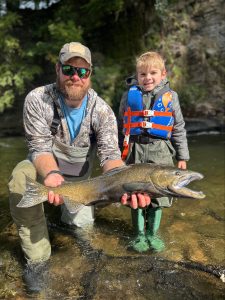
Tony and son Anthony enjoying a fun day at DSR with Guide Brooks Robinson of Syracuse Outdoors Guide Service.
72° / Clouds
Sunrise: 6:50am
Sunset: 7:04pm
195 CFS Pineville Gauge
185 CFS Dam Release
Clouds